The Harappan civilisation was one of the oldest civilisations in the world and it was evidently a Chalcolithic civilization. Without utilising iron technology, the civilisation rose to urbanisation at its peak period, making it significant among other ancient civilizations. Although urbanisation does not mean cities and towns, cities and towns are always a product of urbanization. In this context, Harappan civilisation had cities and towns such as Harappa, Mohenjo-Daro, Chanhu-Daro, Dholavira, Rakhigarhi, Lothal, etc., spread over the whole area where the civilisation was extended. Hence, in this essay, the urbanisation of Harappan civilisation will be studied with special reference to Dholavira. A brief introduction of the Harappan civilisation will be provided in Chapter I, followed by a brief introduction of urbanisation in Chapter II and the urbanisation and its features of the Harappan civilisation as evident in Dholavira in Chapter III.
A brief introduction to Harappan civilisation
1.1. Introduction
Harappan civilisation is considered to be the first ever urbanisation on the Indian subcontinent. The reason the civilisation is referred to as the as the Harappan civilisation is due to the fact that the first significant discoveries of the civilisation were made in Harappa and Mohenjo-Daro. This was the largest civilisation in the Bronze Age.
1.2. Location
The civilisation was located in the Indus River Valley in the north-western part of ancient India, extending over 500 million km2. The civilisation extended from Shotugai in North Afghanistan to Daimabadh in South India as in North to South, from Suktajen-Dor in Iranian border to Hulas in Uttar Pradesh as in West to East. Relatively, it was larger than the area of both the Nile Valley and Mesopotamian civilisations at their peaks.
1.3. Environmental background
The civilisation was based on the Gaggar-Hakra plain and extended over the highlands and plateaus of western Baluchistan, the hillsides of north Pakistan, Afghanistan, north-western India, and north India. So, civilisation was laid over hillside highlands and lowlands, coastal areas, as well as plains, which are ideal for agriculture. The special natural resources that impacted socio-economic interrelationships and social conditions of civilisation could be found within these perimeters.
1.4. Chronology
The Harappan civilisation is a collection of distinctive cultures that cannot be taken as one cultural entity. The three cultural phases of early Harappan culture in 3500–2500 B.C.E., mature Harappan culture in 2500-2000 B.C.E., and post-Harappan culture after 2000 B.C.E. are included in the Harappan civilization. It is considered that the urban civilisation emerged in 2600 B.C.E. with the contemporary emergence of urban settlements, the use of scripts, standard weight measurements, and pottery ware inherent to Harappan culture, urban planning, etc. It is said to have collapsed between 2100-1900 B.C.E.
1.5. Origin and development of Harappan culture
According to the hypothesis which is considered by now, the indigenous Indian population that established the Harappan civilisation was the human society that lived around the Bolan Pass, Baluchistan. This hypothesis is adequately supported by the evidence found at the Mehrgarh site. Accordingly, the peak point of a gradually developed cultural process that started with the establishment of permanent settlements in 7000 B.C.E. was the Harappan civilization. Seven cultural phases have been identified in Mehrgarh and evidence of each phase appears to be an early stage of the features of Harappan culture. Natural resources in Indu, Gaggar-Hakkra valleys, Sauratra, coastal belts, and deserts, as well as the willingness of the people towards change, impacted the development of Harappan culture.
An introduction to urbanisation
Urbanisation does not mean cities or towns. Cities and towns are a product of urbanization. Simply put, urbanisation is the process by which large numbers of people become permanently concentrated in relatively small areas, forming cities.
In historical context, the process includes animal and plant domestication, the emergence of permanent settlements, a surplus of food production, an increase in population, the production of clayware, the development of trade, the gathering of people as communities, etc. During the Neolithic age, hunter-gatherers discovered the domestication of animals and plants. With the domestication of fauna, they needed to move towards the hinterlands for the animals seasonally. With the domestication of flora, the early humans had to settle near the valleys where those earliest domesticated flora were grown. Therefore, they went through semi-nomadic life and established permanent settlements.
Meanwhile, the craft of pottery-making emerged as a result of the requirement for storage jars to store food. The craft evolved from simple, handmade clay pots to terracotta jars with decorations. With settled agriculture, food production was relatively easier than in earlier times. Hence, food security was compromised, and a food surplus occurred. Food security leads the community to have free time on a daily basis and the surplus of production leads to the manufacture of commodities. This merchandise opened access to resources that were not locally available. As a result of the surplus of production and merchandise, in order to keep track of those, writing came into practice.
Meanwhile, the specialisation of craftsmanship occurred, and the first ever complex society with varying full-time professions emerged. Under these circumstances, economical centres developed, and production, buyers, sellers, and professionals concentrated within the vicinity of the center. These centres further evolved into cities, usually with fortifications. Since the cities were incapable of food production, hinterlands outside the city in the vicinity provided food and other essentials to the cities. In order to unite people as a society, a social hierarchy was in the process of being formed, mostly with both political and religious power and later on, the concept of kinship strongly emerged.
This way, the majority of the population concentrating on a small area where they can live without issues for basic requirements or their daily lifestyle can be recognised as urbanization. Gordon V. Child describes this process as the urban revolution. He further stated that the emergence of cities is only one profile of the urban revolution and the whole complex is urbanisation. According to Child’s 10-point model, there are 10 characteristics of urbanisation.
- In terms of size, the first cities must have been more extensive and densely populated than any previous settlements.
- In composition and function, the urban population already differed from that of any village: full-time specialist craftsmen, transport workers, merchants, officials, and priests.
- Each primary producer paid over the tiny surplus he could wring from the soil with his still very limited technical equipment as a tithe or tax to an imaginary deity or a divine king, who thus concentrated the surplus.
- Truly monumental public buildings not only distinguish each known city from any village but also symbolise the concentration of the social surplus.
- But naturally, priests, civil and military leaders and officials absorbed a major share of the concentrated surplus and thus formed a “ruling class.”.
- Writing
- The elaboration of exact and predictive sciences—arithmetic, geometry, and astronomy
- Conceptualised and sophisticated styles [of art].
- Regular “foreign” trade over quite long distances.
- A state organisation is now based on residence rather than kinship (Smith 2009: 10–11).
As seen in these 10 facts, the model of the urban revolution is clearly not about cities. It is about the process of urbanisation, which produces cities. However, Child’s concept does not focus on town planning or the nature of towns, though a few of his points are relatable regarding the fifth cultural phase of the Chalcolithic Harappan civilization. Although some of his points appear to be unrelated to Harappan civilisation, it is evident that some of the reasons Child described have had an impact on the urbanisation of Harappan civilisation.
Urbanisation of Harappan civilisation, as evident in Dholavira
3.1. Introduction
3.1.1. The emergence of/early time of urbanisation in Harappan civilisation
The urbanisation of Harappan civilisation, which evolved from Harappan village cultures, has seven chronological phases, the fourth being the maxim of urbanisation. In order to have a vast understanding of the urbanisation of Harappan civilisation, the pre-urban phases should also be reviewed. Here, the nature of those first 3 phases will be discussed briefly, and then the nature of the urbanisation of the civilisation will be discussed.
As demonstrated by G. V. Child, with the Neolithic Revolution, agriculture began. As seen with any civilisation in human history, agriculture, which started as a simple practice of cultivating crops, evolved vastly when human cultures evolved towards urban revolution. This applies to Harappan civilisation, and according to R. S. Bisht, there were seven sub-cultural regions in the Indus Valley, namely:
- North Baluchistan
- South Baluchistan
- Sindh Kohistan
- Indus valley
- Kuchh, North Gujarat, and Saurastra
- South Gujarat, the Tapti Valley, and the region beyond
- North Afghanistan
These regions had geographical similarities as well as dissimilarities, which determined the nature of the subsistence patterns and economies of the cultures. Agriculture was first put into practice by the early Neolithic human populations in Baluchistan regions. They cultivated crops such as wheat and barley and were attracted to the land that was beneficial for those crops. That led them to establish settlements in those regions, which emerged as village cultures. The spread of population with the spread of agriculture rose with the interconnected trends of production surplus, skilled craftsmanship, pottery, art, and the emergence of elites.
However, agriculture thrived on excellent water harnessing and water management in Harappan civilization. On the other hand, the development of water harnessing and water management in civilisation resulted in the development of the agriculture and relative trends such as surplus resulted in urbanization. Therefore, the nature of agriculture, water harnessing, and water management in the Harappan civilisation marks the phases of the civilisation itself.
- First phase
- Evidence is found to belong to the Mehrgarh period in 7000 B.C.
- Three subspecies of wheat and two subspecies of barley have been cultivated, as evident by the development of domestication.
- Second phases
- Wheat, barley, and jute have been cultivated, evidently.
- Although the above crops in larger fields needed to be irrigated, no archaeological evidence of irrigation structures has been found so far.
- Third phase
- A trench has been found, which might indicate irrigation work dated back to the 4th millennia B.C.
- The cultivation of grapes, for which an irrigated water supply was a necessity, was introduced to the region.
- Vast use of traditional Baluchistan irrigation work such as the Karez (tunnel) system, well system, and garband (irrigating crop fields using dry masonry walls).
- Fourth Phase
- the highest point of agricultural irrigation.
- Using the knowledge of water management developed from the irrigation work, other structures have been created for other utilities. The great bath in Mohenjo-Daro, the well and drainage system, the pits of drainage system in Harappa, the great dock of Lothal harbour, the excess water drainage system in Benawali, and the wells in Kalibangan provide evidence structurally as well as their placement in the townplan, showing how important water harnessing and water management were in the civilization. So, it is clear that this knowledge was within the pre-urban Harappan civilisation and was one of the reasons for the civilisation to flourish as an urban civilisation.
3.1.2. Urban phase of Harappan civilisation
As shown above, the Chalcolithic Harappan culture had several stages. Its peak was the urbanisation of the Harappan civilization. That is, the urban civilisation phase. That phase is referred to as the Urban Harappan Period or the Mature Harappan Period. The features found in the Harappan civilisation at this mature stage have been revealed through the currently available archaeological evidence. The Harappan civilisation was widespread. It consisted of urban and non-urban rural areas, diverse in size and function but with some inherent common characteristics. Such features include the design of cities with defensive walls and gates, the subdivision of settlements, the drainage system, structures made of burnt bricks, the standard scale of a brick, pottery, writing, similarities in craft products and technology, seals, weights and measures, external trade, etc.
Those characteristics provide the opportunity to identify the fields as belonging to the Harappan civilisation, regardless of their size or urban or rural nature, and to present those characteristics as the characteristics of the Harappan civilization. In addition to this, by examining the 10 points presented by Gordon Child under the urban revolution, the form of the city of Harappan civilisation is understood. By focusing on the features that should exist in an urbanisation as shown by Child and the features that have been identified so far based on the evidence discovered from the entire Harappan civilisation, the form of the urbanisation of the Harappan civilisation can be studied through the archaeological evidence received from Dholavira city.
Possehl has presented some of the characteristics of the city of Harappan civilization. Those evidences led to the transformation from the pre-urban Harappan civilisation to the urban Harappan civilisation, which was suddenly taken over by the Harappan civilisation in a short period of 100–150 years, around 2600 B.C. He also points out that some of those characteristics continued to exist. Those facts can be stated as follows:.
- well-designed and manufactured seals with high-quality animal motifs
- Town planning
- Large stage made out of bricks
- digging wells
- Drainage
- Grid town plan, etc.
- Widely used units of weights and measures
- New vast variations of lifestyle, such as the collection of pottery with a wide variety of patterns
- Development of innovative artworks and designs, such as new human and animal figures
- Harappan pottery with designs painted in black on red paint
- The basic trends of urbanisation
- Social stratigraphy
- The emergence of state and political structures
- The advancement and specialisation of crafts and industries
- The creation of cities and a new form of social regulation
In examining these facts, a situation similar to the trends that can be seen in a city presented by Gordon Child can be identified. But, in focusing on the Indus Valley Civilisation, it seems that another point should be added: the emergence or spread of modern sciences.
3.2. Discussion
Considering the above theories, the form of urbanisation of Harappan civilisation can be studied under the following headings through the archaeological evidence found in Dholavira city.
- form of Harappan urbanisation based on the location of Dholavira City
- city design or town planning
- drainage system
- water management
- advanced agriculture
- advanced commercial activities
- crafts, skilled craftsmanship, and technology
- diverse composition in population and full-time artisans
- art
- standard units of measurement
- elaboration of exact and predictive sciences
- document system
- Religions and beliefs
- socio-political organisation
3.2.1. Form of Harappan urbanisation based on the location of Dholavira city
Among the archaeological evidence from Dholavira city, before referring to the artefacts or the built environment, an area that needs to be focused on the subject of the thesis is the location of Dholavira city in the geographical expansion of the urban phase of the Indus Valley Civilization. Dholavira is the main city located in the semi-arid regions of Gujarat and Saurashtra in the Harappan civilisation, which emerged centred on three main geographical regions, as emphasised above. As mentioned in the introduction to this chapter, the Harappan urbanisation was not a civilisation consisting only of cities but a combination of rural and urban areas. The existence of urban and rural centres with mutual connections can be confirmed through archaeological evidence found in Dholavira city and other places found in the vicinity of the city. Dholavira was a commercial city and the agricultural surplus of the rural areas had to go to the city for the food needs of the city, with port characteristics that were a necessity of the city, namely;
- Jhandiasar (230 53′ N, 700 11E)
- Bambhanka (230 49′ N, 700 19E)
- Saran (230 55′ N, 700 13′ 50” E).
It could also be identified that the fields are located on the island where the city is located. Based on this evidence, it can be said that the activity of Dholavira city in Harappan civilisation was connected with the surrounding non-urban areas. These evidences related to Dholavira city reveal that the areas with rural characteristics that nourished the city based on the needs of the city and the urban elements that are directly related to the city’s activities were widespread in the areas with those rural characteristics. Accordingly, it can be said that the urbanism of the Indus Valley civilisation was not limited only to those cities but spread throughout the civilisation, and it can be determined as a unique feature that can be seen in the urbanism of the Harappan civilisation.
3.2.2. Town Planning
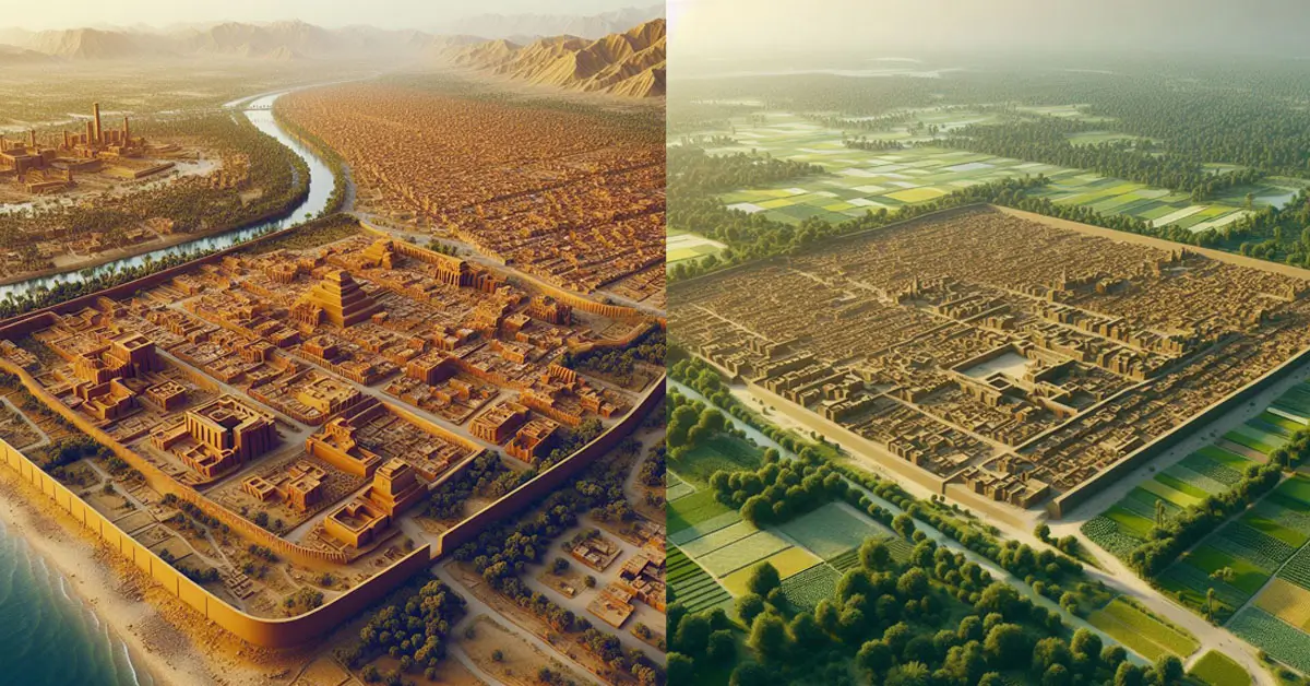
Town planning can be identified as a major characteristic of the urbanisation of Harappan civilisation. It is a clear fact that although those cities marked the rise chronologically, they were not born of random construction but were built and maintained after formal pre-planning. According to Gordon Child, the first characteristic of an urban economy is population density and population expansion. That characteristic is implied in the size of the city of Dholavira. It is a clear fact that the ability to build and maintain such a large city is directly dependent on the population.
The city walls of the Harappan civilisation were designed in a grid pattern. Among the archaeological evidence found in Dholavira city, it can be pointed out according to the built environment of Dholavira. Dholavira city, spread over an area of about 100 hectares in three layers (upper city, middle city, and lower city), is established in synchronised with polar directions. It is clear that the construction of city walls, residential buildings, and large water pools is also adapted to that directional construction. That is, about 90 percent of the structures are built by parallel north-south and parallel east-west walls, foundations, walls, etc. The drainage system, road, and street systems perfectly reflect this grid pattern. The regular system of roads and streets and the regular drainage system dividing the city into rectangular sections extending over the entire city, with north-south and east-west roads and drains connecting each other at 90-degree angles, are evidenced.
Also, the bricks used for the construction of the city were of standard size and the size ratio of a brick was 4:2:1. The architecture of Dholavira city was built using stone as the predominant raw material. Thicker structures, such as wall walls, are built with mud bricks and the parts exposed to the external environment are built with stones. It is possible that the unbaked bricks were intended to be protected from rain damage, or because they were strong defensive structures in the city, they were made of stones. If not, in the Indus Valley Civilisation, cities such as Mohenjo-Daro and Harappa, which were located in the alluvial plains with minimal natural resources such as rocks, produced bricks and burned them as building materials using clay, which is the raw material that can be obtained from that area. It is possible that stone was the predominant raw material in Dholavira, as it is abundant in the region. According to the excavation of the lowest soil layer of Dholavira city, the structures built with stone were discovered in the stages before the Harappan urbanisation, and it seems that the city dwellers turned to the more easily available durable materials. Also, it can be understood about the resource consumption pattern of the entire Indus Valley city. However, considering the city design, it can be said that Harappan civilisation focused on using sustainable materials for their creations and making the best use of regionally available natural resources.
The construction of large-scale architectural works was a characteristic of city design and this is confirmed by the fortification walls, inner cities, dams, etc. found in the cities spread throughout the Indus Valley. It illustrates the 100 hectares of Dholavira city’s ramparts, including the city fort, the large group of water pools, and the dams that cross the Manhar and Mansar waterways. According to the way private houses were built, it seems that the lower town was used for that purpose. Although the town plan of Dholavira town can also be identified as a central town, it can be recognised that the structures contained therein are what can be considered public buildings. The remaining structures prove that the lower city was separate for residences. In the cities of the Indus Valley, every house is built facing the central space and the house has an entrance from the street. Also here, as a very important feature, it is positioned so that an outsider cannot see the inside of the house along the house entrance. Accordingly, the focus on spatial planning during the Harappan urban period is reflected.
| Feature | Measurements (in Meters) | |
| Length | width | |
| Lower town (entire city) | 771.1 | 616.9 |
| Middle town | 340.5 | 290.5 |
| Ceremonial ground | 283 | 47.5 |
| Castle (inner) | 114 | 92 |
| Castle (outer) | 151 | 118 |
| Bailey | 120 | 120 |
The evidence of the cities of the civilisation proves that there were one or more wells for the use of several houses, and thus the mere arrangement of wells does not seem to be a characteristic of the city. It suggests that the provision of public and private water needs was a characteristic of the Harappan civilization. That is, in comparison with Dholavira city, it seems that the need was met by the wells in the alluvial plain, where the water easement was close to the Indus River, where the city of Mohenjo-Daro is located. There is evidence that that need was met by water tanks in Dholavira city. Also, it seems that as much water as possible was collected in the city itself to match the water shortage in the semi-arid region where the city of Dholavira is located. It seems that attention was paid to large water storage structures rather than the structures built to be used by a few families for personal water needs.
Also, it can be said here that the construction of common public buildings can be recognised as a characteristic of Harappan City, as shown by Child. Every city had common welfare features like a wall, a water source, and a drainage system. The archaeological evidence found in the city suggests that Dholavira was the main commercial centre in an area that can be identified as a region around Lothal and Gujarat. In many other cities, there are inner cities and outer cities, i.e., the central structure of the city is surrounded by a wall located on a high mound and the residences of the common people are established around it. But Dholavira City has been designed to have three parts: the upper city, the middle city, and the lower city. Also, beads, semi-precious stones, shells, lead, copper, silver, etc. are found in the city in very large quantities. Accordingly, it seems that this city was designed for commercial activities. The upper city usually houses the ruling class, the priestly class, or some elite group. It is clear that the lower city was reserved for residences. The central city was dedicated to craft industries, the sale of manufactured goods, trade, etc. In this way, according to the presence of Dholavira as a commercial centre, it can be said that the wall was built to cover the entire city for its protection. Accordingly, Dholavira city can be identified as a commercial city that existed in the city of Harappan civilisation in the investigation of the archaeological evidence related to the city design and the artefacts found. It is evident that there was a classification of cities according to utility in the urban planning of the civilisation and that the form of the cities changed accordingly, and that both the points of having the opportunity for those changes and preserving the uniform form were maintained in balance.
3.2.3. Drainage System
It seems that the drainage system was an integral part of the Harappan civilisation’s city design. A drainage system made of stone can be seen in Dholavira town, designed for the purpose of collecting rainwater, discharging excess water, discharging unhygienic water, etc. In comparison with other major cities, Mohenjo-Daro and Harappa seem to have drainage systems made out of burnt bricks. What is striking here is the emphasis on sanitation and hygiene during the urbanisation of the Harappan civilization. The unhygienic water discharged from the houses goes through a small drain to a large drain on both sides of the road, and that big drain is sent out of the city through several pits and only water is released into the environment except for non-liquid waste. It is also special that this drain system is covered on the surface. According to the evidence from Dholavira city, it is possible to understand how this type of drainage system is covered with a surface to prevent water leakage by using stone slabs. Also, a specially prepared drainage system has been constructed in Dholavira city and the city limits the amount of water that collects on the surface of the city due to heavy rains. The water that collects throughout the inner city limits is directed from one point through a drain to the adjacent Bailey structure site in the west. Also, the soakage jar found in connection with the drainage system, the pot where the water is filtered and poured out, and the water pipe with two layers made of stones are among the most important archaeological evidences. It seems that Harappan city was built with a specific vision, as this situation is seen in other Indus Valley cities as well, as is seen with this drain system in Dholavira city. And this drainage system is found in every city and non-urban settlement of the civilisation, and thus the urbanisation of the Harappan civilisation can be named as the first unified urbanisation in the world.
3.2.4. Water Harnessing and Management
Water management was also one of the main characteristics of the city, just as good water management during its development led to the emergence of the Harappan civilisation as a city. Strong evidence is found in cities located in the fields of Harappa, Mohenjo-Daro, Lothal, Banawali, Kalibangan, etc. When those evidences are taken in common with the evidence found in Dholavira city, it can be said that water management was one of the aspects of the form of Harappan city. That is, the evidence related to water management is surprisingly found among the archaeological evidence from Dholavira city, and the evidence revealed in Dholavira through the receipt of similar evidence from other cities should be recognised as a characteristic of the city of Harappan civilisation, not about water management unique to Dholavira city. Among them, it should be mentioned that according to the geo-physical location and the climate, there are also forms and characteristics peculiar to the city of Dholavira.
Harappa had a unique place in the city in the construction of water structures with a variety of terrain. The Harappan civilisation is considered to be the first human civilisation to construct a well and obtain underground water. As shown above, it seems that wells were built in several cities during the Harappan civilization. Also, the reservoir at Lothal, the bathhouse at Mohenjo-Daro, the latrines, the sanitary sewer system and numerous private and public wells are typical examples of water engineering in the Harappan civilization. The city of Dholavira seems to add many important archaeological pieces to these illustrations. Comparatively, it seems that Dholavira city was ahead of other cities in terms of water management. There is clear evidence that there was a formal drainage system in Dholavira City that was not found until then. Dams or embankments join the chain of interconnected reservoirs.
Dholavira city belongs to a semi-arid climate zone. Annual rainfall in summer is between 700 and 100 mm. Rainfall is 200 mm or less in winter and temperatures exceed 40 degrees Celsius in summer. Geological research has revealed that the very active wet phase lasted from 8000 BP to 3000 BP and ended in the present state. Here, a uniqueness that can be seen in the urban planning of the Harappan civilisation is highlighted. That is, in all the cities located in the three main geographical regions where civilisation has spread, there was a type of water management specific to each region. That is, instead of establishing uniform structures in every city, it seems that they have approached the local type of structural construction, considering the common utility. Comparatively, Mohenjo-daro, Harappa, Lothal, Rakhigarhi, Suktajen-Dor, and Dholavira all show that the common water supply was intended to be a sustainable water supply. There, it is not seen that the water received during the rainy season is collected and kept for use in the less rainy season through a uniform method. The fact that various methods were used for that is explained through the archaeological evidence. The water management system of Dholavira city is taken as an illustration and its main elements are:
- Reservoirs,
- dams,
- Wells, and
- Irrigation systems.
In the water management system of Dholavira city, there are several well-planned rectangular reservoirs. In comparison, the main pool is 73.4 metres long, 29.3 metres wide and 10 metres deep, larger than the Mohenjo-Daro Great Bath. A flight of steps has also been constructed to descend into the pool to reach its water level south of the inner city palace. A pool with similar characteristics has also been built to the east of the palace. The rock in the pool south of the palace has been cut to a depth of 0.31 metres below the surface of the bottom of the pool. It is accepted that these water conservation pools may have been used to effectively control the amount of water received as a remedy for the water shortage in the area. According to Bisht, the Harappans were extremely anxious to store as much or almost all of the water that ran off after the rains, which is reflected in the 16 or more water conservation basins created around the city of Dholavira within the city walls. Researchers indicate that approximately 36% of Dholavira city area, 17 hectares, has been reserved for water storage and related activities. All the pools are watertight, with side walls made of interlocking stone blocks cut down to the bedrock. The water management system designed to prevent water leakage can be recognised as a unique feature of the Harappan civilisation.
Also, it seems that the Manhar, the river flowing south of the city and the Mansar, the river flowing north of the city were crossed by constructing several embankments and the water was brought into the city. They seem to have used measures to control the velocity of the water in the construction of abutments that crossed the natural stream to bring water to the city. Because the velocity of the flowing water is a hindrance to tying the main anvil as well as keeping the anvil stable, several abutments have been constructed by putting rock blocks and debris in the waterway above that anvil. It seems that arrangements have been made to construct the main anvil in a stable manner. Accordingly, it seems that a system of dams has slowed down the natural flow of water and taken it into the city. The construction of wells is evident from the evidence found in the cities of the Harappan civilization. Burnt-bricked wells are also found at Mohenjo-Daro and several walled wells made of stone (roble-type stone according to the classification of rocks in geology) with mortar are found at Dholavira. One of them is a set of steps made of rough stone slabs to reach the water level. By having these wells constructed, Dependence on underground water during water scarcity in Harappa urbanisation and channelling the rainwater to reservoirs to store it for consumption as long as possible during water scarcity. An integrated plan to meet water needs throughout the year without relying on only one method, such as diverting flood water into the city and storing it in reservoirs, damming the natural waterway during low water periods and taking the rising water to the city, It can be said that water was collected, stored, and consumed in a highly sophisticated manner. Also, the bathroom structures in Banawali town and similar structures found in Dholavira town near the rectangular buildings also reveal the luxurious idea of water consumption. That is, the opportunity to bathe in private residences in the city has been created.
Also, the efficient water management of Dholavira city is reflected in the irrigation system. Irrigation systems are designed to bring water into the city through dams crossing the Manhar and Mansar monsoon watercourses flowing north and south of the city. The irrigation system and the aforementioned drainage system have been established in the city plan in such a way that they do not mix with each other. It can be seen from the evidence that can be seen in almost every city that special attention was paid to irrigation and drainage works under water management in Harappa Municipality. Although it consisted of many cities that were distant from each other, it can also be recognised that there was a simultaneous existence.
Thus, under water management, which can be considered one of the essential elements of the city of Harappan civilisation, it seems that a complete system was established in terms of collecting water by making maximum use of natural water sources, consuming that water in a formal manner, and disposing of the waste water in a formal manner. Dholavira city implies that an uninhabitable and difficult-to-live area was made habitable by hydro-engineering works.
3.2.5. Advanced agriculture
The main economic pattern of the Harappan civilisation, which had a subsistence economic pattern, was agriculture. It was mentioned above that the development of agriculture also laid the groundwork for the development of civilisation as a city. According to Gordon Child, the production surplus caused by the development of agriculture and the population growth due to food security lead to the birth of a city and become a characteristic that marks the existence of a city. It is confirmed through archaeological evidence that there was a subsistence economy in which agriculture was the dominant factor in the Harappan civilisation.
Evidence of barley and wheat grains, evidence of the cultivation of paddy, dates, cotton, etc. is found. It can be said that the area around the city may have been used for agriculture through the evidence of large-scale water collection and sophisticated consumption that can be seen in Dholavira city. Also, sophisticated water conservation and management, which is a major part of the urbanism of the Harappan civilisation, suggests the development of agriculture. It was possible to point out the technical use of water handling as the ultimate result of improving irrigation for agriculture.
3.2.6. Advanced commercial activities
Advanced commercial activities can be pointed out as one of the characteristics of the Harappan civilization. A unique network of exchange and commerce existed for the gathering and distribution of raw and finished goods within and outside of civilization. The archaeological evidence found in Dholavira city reveals much information about the trade items exchanged in those commercial activities, the areas where they were exchanged, how the raw materials were procured, the areas from which the raw materials were procured, etc. While the other major Indus Valley cities of Mohenjo-Daro, Harappa, Ganeriwala, and Rakhigarhi are located in an alluvial plain with few rock resources, Dholavira is located in an area rich in rock and mineral resources. Agate, carnelian, chalcedony, limestone, sandstone, basalt, gabbro, gypsum, calcite, amazonite, and a large number of other materials have been identified in the field and can be sourced from Kutch or Gujarat. But in particular, metal deposits of lead, silver, and copper appear to be rare in the region. Hence, to obtain them, the people of Dholavira may have had to focus on the far-flung border areas of Gujarat and beyond. Therefore, the material made from these materials is the primary factor in uncovering the remote resource acquisition network of Dholavira town. Thus, through the study of the isotopes of lead metal in association with the metal artefacts, information has been revealed about the areas where they were brought to Dholavira. Accordingly,
- The southern part of Balochistan province in present-day Pakistan,
- Ganeshwar in Sikar district of North Rajasthan
- Ambji-Deri (275 km west) on the Gujarat-Rajasthan border.
They have been proven to have been brought to Dholavira from the above three main source areas. In addition, metal has also been brought from a source in the Tosham hills of Haryana. According to the analysis of the material of the silver artefacts, it appears that they were brought from the deposits associated with the prominent sites of Ambji-Deri. Analysis of copper artefacts has confirmed that a source of copper brought to Dholavira is located in the eastern Arabian country of Oman. It is considered that Dholavira city is located near the sea and it would have been easy to gather resources from far away. However, this shows that copper was the main metal in the Chalcolithic Harappan civilisation, which was one of the craft industries carried out in the city of Dholavira, and that it was brought from faraway places.
There is no doubt that transportation was an essential part of the trade that took place and that it must have been at an advanced level. There is evidence that suggests that transportation was carried out by people on land by caravans and oxen carts and on the backs of animals such as camels, goats, and cows, and by water on rivers and oceans by canoes, ferries, and other small and large-scale vessels. Terracotta designs depicting scenes of sailing ships associated with seals and bullock carts stand out among them. Among the archaeological evidence found at Dholavira, it is significant that researchers have found the sources of metals and the sources of rocks and minerals that have been brought from and transported to very distant areas. In such relationships with remote areas, transportation must definitely be developed. According to Gordon Child’s idea of full-time artisans, among the professionals were transporters. Although there is no direct evidence that a group of people lived in Dholavira specifically for the purpose of transportation, there is strong evidence that proves it indirectly. The well-planned and well-constructed wide street system of Dholavira, as in other Harappan cities, illustrates that raw materials were brought to Dholavira from far away and finished goods transported far away from the city. Also, there are several piers located on Kadir Island that are believed to have been used for the needs of Dholavira town.
Thus, it is clear how the above-mentioned exchange network was important in the commercial activities of the Harappan civilization. It can be said that the archaeological evidence from the city of Dholavira reveals information about the trade of Durum Katara, which is among the ten important characteristics of urbanisation, as described by Gordon Child. That is, this confirms the advanced commercial activities that were characteristic of the Harappan civilisation.
3.2.7. Crafts and Technology
Economic affairs and art-related industries are prominent in Harappan urbanization. Those activities are spread over a wide range of Among them, many industries related to different types of minerals were used for industries in different fields. Among them are marine shells, ivory, carnelian, steatite, faience, lapis lazuli, gold, and silver. Artisans produced goods for domestic use (pottery and utensils), for social life (seals), jewellery for personal use (rings, beads, and necklaces), for the elite market, and for the long-distance trade. According to the anthropomorphisms spread throughout the Indus Valley, it seems that the products were made according to some standards. Thus, all types of pottery found throughout the Indus Valley Civilisation were found in Dholavira.
Also among the metal artefacts recovered from Dholavira city are ingots, rings, sticks, scales, metal sheets, metal fragments without a definite shape, etc. Fifteen Artefacts made of silver metal are found. It seems that the artisans of the city produced finished goods using metals brought as raw materials to the city through the long-distance trade. Thus, various crafts and the full-time artisans who mastered them can be identified among the characteristics of the urbanisation of the Harappan civilisation (Bisht).
It can be recognised that shell-related products were developed among the industries of the Harappan urbanization. Among them, it seems that Gujarat took the lead. According to the location of Dholavira city, Dholavira can be identified as an important centre for shell production due to the fact that the area around Gujarat is located in an oceanic region.
It can be recognised that different types of rocks have been used for different purposes. Stone tools made of amethyst and chalcedony, seals carved from steatite, beads made of faience, carnelian, etc. are found at Dholavira. Among these evidences belonging to the urban phase of the Harappan civilisation, carnelian beads have been found in the royal cemetery of Ur in Mesopotamia. It seems that long-distance trade is a characteristic of Harappan urbanization. Also, as discussed above, it seems that the natural environment of the city of Dholavira, due to its geographical location, made it a city where the industrial production of the Harappan civilisation was carried out. It can be pointed out as a characteristic of Harappa City that the cultural activities that develop make the most of the natural environment.
Also, the use of rocks reflects the technological and innovative ideas of the Harappans. Their focus on semi-precious stones is considered unique. That is, the rest of the civilisations in the world were attracted to ruby stones, while the Harappans were attracted to semi-precious stones like carnelian and lapis lazuli. Scholars point out that the Harappan culture focused on the creation of power and wealth rather than the accumulation of power and wealth, as reflected in the cities they created and rock beads (Agrawal, 2007: 323).
Copper and bronze metals were the main metals used during this period. Axe blades, ornaments, standard weight measures (scales), etc. made from them can be identified. Also, evidence from Dholavira city has confirmed that copper was imported from a deposit in Oman, an Arab country. Accordingly, it can be seen that raw materials were brought from sources within and outside the civilisation, and the demand for copper-related products was such that it was imported from a very distant area such as Oman, and accordingly, it can be said that the craftsmen of that civilisation were proficient in metallurgy. Also, although copper anthropomorphic figures are found in large numbers in cities with a large and developed economy during the urban stage of civilisation, they are not found in rural areas. Thus, it can be understood that the use of copper was not essential in everyday life but was a representative of a luxury practice that symbolised wealth and social status (Agrawal, 2007). However, most of the copper metalwork found as ornaments or containers is not recognised as hidden. Most of them are burial artefacts, and bronze artefacts are also found in the same way. Corroborating this situation, Dholavira city provides a large amount of metallurgical evidence, which is found in finished products, raw materials, and manufacturing waste. These metal artefacts found in Dholavira city have so far revealed information about the craftsmanship, the pattern of metal usage in Harappan city, the long-distance trade network for the supply of raw materials and the trade of finished products through lead isotope testing.
As a whole, one must have high technical knowledge to carry out all industries. Among them, in the metal industry, metal extraction, smelting, mixing, etc. are the main opportunities. Information about the technological advancements achieved during the Harappan urban phase is revealed in the investigation of bead production. Drilling pins used for drilling beads occupy a very important place among the archaeological evidence received from Dholavira. The rocks used for the beads can be brought to different stages of crystallisation by heating them to different temperatures. It is evident from the findings of the beads that there was a high level of technical knowledge to have an understanding of those phases and the appropriate temperature ranges. Also, bead piercing was an extremely delicate task that required a high level of technique as well as mastery of craftsmanship. A large number of such beads come from Dholavira and it is identified that bloodstone beads were a very important finished product in long-distance trade.
3.2.8. Diverse folk compositions and full-time artists
The presence of full-time artisans was identified by Gordon Child as a characteristic of a city. Unlike the society that existed until then, due to the surplus of agricultural products, people might have had free time as leisure time so new ideas and time for testing new ideas might have been available. When looking at the Harappan civilisation, it seems that the emergence of full-time artisans was one of the main reasons for the emergence and existence of urbanization. According to the archaeological evidence common to the rest of the areas found in the vicinity of Dholavira City
- Priestly or ruling elites,
- Officers,
- Traders,
- Carriers,
- Full-time artisans, etc.
have been elements of the social organization. Every archaeological finding in the city reveals that full-time artisans lived in a society consisting of a population composition with different roles. Well-planned city walls and large architectural designs, bailey courtyards, town planning, and masons and architects with specialised knowledge of construction. Dholavira town is unique in that the watertight drainage system is built of rock, just as it was built of bricks on the alluvial soil of the Indus Valley. It can be said that there were technicians with expert knowledge in that work to carry out complete water supply and drainage works, which were prepared so that water does not leak. Also, the elite group lived in the city due to its high location; the merchants lived from the products related to handicraft industries and seals, etc. from the central city; the artisans lived from the raw materials, finished products, and waste related to pottery, metals, rocks, and minerals; and they engaged in the transportation work related to those activities. In the production of beads, high technical knowledge and expertise are required for activities like melting, piercing, and polishing of beads. Through the equipment and tools developed for that purpose, it is evident that there were experts in every field. Accordingly, it seems that the birth of a class society based on profession, knowledge, and role was important for the birth of Harappa urbanization. That characteristic can be seen among the characteristics of Harappan City, which is reflected in the city planning, procurement of raw materials, production, trade of finished products, transportation, elite market goods, etc. in the vicinity of Dholavira City.
3.2.9. Art
The presence of a remarkable artistic element is a characteristic of urbanisation; a situation similar to Gordon Child’s idea can be seen in the urbanisation of the Harappan civilization. It is implied in the inquiry that the artistic activities started with the creation of pottery. This is confirmed by examining the growth of pottery. Artistry is gradually brought out by the designs added to the outer surface of the pottery before or after drying and by the shape and form of the pottery. Pottery from the Indus Valley is meticulously made of fine clay, without imperfections, and fired in the same manner in all hands. A red coating is applied and the designs are painted black. There is a variety of pottery painting and different designs are used. Interlocking circles, fish figures, papyrus leaves, etc. are among them. Common shapes of urban Harappan pottery include S-shaped jars, the dish-on-stand, and perforated cylindrical jars. The diverse collection of pottery found at Dholavira represents the pottery types, forms, and design patterns of the entire Classical Harappan culture. By finding all kinds of pottery evidence, it is confirmed that there was remarkable art in the urbanisation of the Harappan civilization. According to scholars like Vasant Shinde, Dholavira pottery is unique due to the use of white colour in the pottery of Nausharo-Dholavira and the use of black colour in other cities.
The widespread terracotta anthropomorphic figures throughout the civilisation imply that there was a unique opportunity for terracotta creations in the Harappan civilization. Terracotta art from Dholavira includes small sculptures and seals depicting bulls. Excavations at Dholavira have yielded a large number of essential artefacts from the classical Harappan civilization. These include steatite seals, terracotta seals, carved carnelian, other semi-precious stone and faience beads, shell bangles, amber blades, terracotta cows, female figures, and copper objects. Extremely rare rock carvings of human and animal figures have also been found in this city. The main craft industries in Dholavira were concentrated in the western Bailey area and the central town in the northern part. The southern part of the palace may also have been used for these purposes. Also, through jewellery produced by full-time artisans, one can get an idea about the state of art in the city, not just technology. It is correct to consider the bangles, beads, necklaces, etc. using semi-diamond stones as not only the results of technological development but also the results of artistic thinking.
3.2.10: Elaboration of Basic Sciences
During the urban phase of the Harappan civilisation, there was an elaboration of specific and predictive sciences. Among them, astronomy, geometry, and arithmetic are important. Astronomy may have been useful for many purposes, such as finding routes (a navigator) and accurately calculating information about crop seasons, especially during sea voyages. It can be said that they had a high knowledge of geometry, as the square grid plan of the cities of the civilisation has been well-oriented and well-positioned in a very precise manner. Arithmetic, as well as geometry, would certainly have been useful in construction and an essential science in commerce. In handling water, it seems necessary to have knowledge of hydro-engineering science (hydrology). This is confirmed by the maximum water harvesting and water management evidence received from Dholavira City. The remarkable expansion of this type of modern science and the focus on science are reflected in the very unique constructions found in the city of Dholavira.
One of the reasons that made Dholavira unique from other structures in that city as well as from other Indus Valley cities was the structure called Bailey. This structure is located on adjacent land to the west of the main palace of the city. It is evident from the extant foundations that it was a rectangular structure with 13 rooms. Adjacent to this structure, its northern, western, and southern areas are flat empty areas, and they are adjacent to the city mound in the east. Thus, a large space appears for this structure. According to the form of the present remains of the construction, some of its distinctive features can be identified.
The rest of the structures in Dholavira city are built according to a rectangular pattern and circular but square sub-structures can be seen within this structure. It has been suggested that this Bailey structure belongs to the late Harappan or post-Harappan period. Also, it is believed that the structure belongs to an earlier period. According to the researchers, the Bailey structure represents a unique aspect of the Harappan city of Dholavira.
When looking at the plan of structures such as circular rooms, it is considered that structures with a rectangular plan are not used as houses due to reasons such as lack of parts that are considered to be reserved for bathing, etc., not being large enough to be used as houses, being a single room with one entrance, etc. Also, it seems that this structure was built during the height of Harappan urbanisation by filling the ground of the earlier constructions. According to the researchers commenting on the utility of this structure, it has been experimentally shown that this reveals the interest and understanding of astronomy in Harappan city. Researchers reconstructing the superstructure of the circular structures show that a circular hole in their base allows light to fall into the chamber, which allows them to observe the annual path of the sun. It is pointed out that these structures are able to accurately indicate the solar equinox in relation to the summer and winter seasons. In particular, the holes indicated by the researchers to be in the floor of the circular chamber to the west show how the sunlight falls into the chamber and how it falls throughout the year, and the boundary of the circular wall of the chamber is marked by the shadow of the sun. Also, it is pointed out that the shadow created by the sunset on the day of the solar equinox by the walls bound from east to west in front of the entrance of the western chamber is very precisely directed to the entrance of that chamber. Thus, they point out that capturing the course of the sun has been done through this structure. It also shows that the construction of this entire Dholavira city is about 6 degrees off true north, correcting it and placing the Bailey structure to true north. The city of Dholavira is tilted about 23 degrees from south to north and the Bailey structure has an inclination of 23.5 degrees from south to north. This would allow a southern observer to see the North Star along the high spatial boundary of the Bailey structure, the researchers point out. They indicate that these characteristics of the base may have been maintained unchanged during the construction of the walls. Also, in this construction, the right corner of the structure can be seen with rectangular sections reserved for rafts, which can be thought to be for observing the stars. Accordingly, it seems that this structure may have been used as a calendar, as a star observatory and in a related field.
In the analysis of this kind of data, it can be said that Dholavira city is unique because no construction or archetype similar to this structure has been reported from any other place of the Harappan civilization. However, this reveals the advanced technical knowledge of astronomy, helio-geometry, the concept of altitude, latitude, etc. among the people of Dholavira and thus it can be understood that the use of advanced sciences took place in the Harappa Civilization. According to Gordon Child, being the source of those advanced sciences, their use and improvement are among the reasons for the birth of a city as well as the characteristics of a city. According to these facts from the city of Dholavira, it can be seen that these sciences were also a distinctive feature of Harappan urbanisation.
3.2.11. Document system
At the peak of the Harappan civilisation, the script emerged. The main difference between the urban Harappan civilisation and the pre-urban Harappan cultures is the absence of writing. By the time of the urban phase, it can be recognised that, along with their advanced commercial activities, a written system was developed to indicate the ownership of goods, to indicate value, to record transactions, to calculate, and to record socio-political or historical events (Fairservis, 1983). However, information about the origin and evolution of the writing system of the Harappan civilisation has not been revealed and has not been read so far. The main evidence for the existence of an advanced writing system among the people of the Indus Valley is from seals, clay or faience tablets, ornaments, pottery, etc. Short texts are written on them. The signboard from Dholavira is very important here. This document was found in the form of a 10-character text on a board near the northern gate of the city. Although the current society has not yet been able to read and understand it, it provides strong confirmation that there was advanced writing during the urban phase of the Harappan civilisation.
3.2.12. Religious Beliefs and Beliefs
It is accepted from the archaeological evidence that several religious faiths and beliefs existed in the Indus Valley. It is believed that there may have been religious practices such as worshipping the mother goddess, worshipping the ngam, and t treating the cow as a deity. These ideas have been expressed by using terracotta statues, models of Lingam, seals, etc. from the areas where civilisation spread. The facts found in burials reveal that there were rituals associated with death. Also, a burial ground has been found in Dholavira town. The cemetery is located about 300 metres west of the town. Cist burials have been found in those cemeteries, and pottery, ornaments, terracotta designs, etc. have been found in the cemeteries. Although no skeletal evidence has been found so far, according to the evidence received, it is enough to state that the urbanisation of the Harappan civilisation was a civilisation that used systematic burial methods, such as funeral rituals.
3.2.13. Socio-political organisation
Evidence of political organisation has not been found yet, even in its urbanisation, the peak of the Harappan civilization. According to the division that can be seen in the city planning, including the city and the suburbs, it is speculated that a ruler or priest may have led the society. There is hardly any other archaeological evidence to support that hypothesis. Since Dholavira was a commercial city, it seems that part of it was added as a central city for commercial activities. Also, the characteristics of the above-mentioned city and the hinterland are revealed in the city of Dholavira. And according to the deposits in the cemetery, an idea is presented about a certain social stratification. There is no evidence of a powerful administrative centre or a large army in any of the cities, which is a distinctive feature of the city of this civilization. It seems that the characteristic is confirmed by the fact that the same evidence has not been found in Dholavira city.
It is said that due to the unavailability of iron technology and the unavailability of evidence of a fast communication system, there was not a united and uniformed political system but there was advanced uniformity in cultural and technological aspects of Harappan urbanization. In terms of urban characteristics, the similarity between the city of Dholavira and the city of Harappa in the upper Indus Valley can be recognised in aspects such as urban planning, water management, seals and pottery, etc.
Conclusion
The above discussion reveals that the urban phase of the Harappan civilisation emerged chronologically and was an urban civilization. It can be said that almost every characteristic that was glorified in the urban phase from the Neolithic revolution and gradually came to the urban phase was practiced for hundreds of years as a rural civilization. It seems that the Harappan civilisation developed with the development of agriculture, the growth of the population as a mutual result, leisure, and the development of irrigation. Through the strength acquired economically and the skills acquired in the meantime in industries and other fields, people with expertise in various activities of society were born. It can be said that cities were created based on their efforts to change the environment to suit their growing economic and social lifestyles. Accordingly, the urbanisation of the Harappan civilisation that emerged was nourished on the foundation of the wealth of knowledge acquired until then. It is an important fact that formal, planned cities emerged on the basis of previous construction. According to the facts from Dholavira city, the prominent features of Harappan city are the uniform cultural and technical equality, concern for hygiene and health, interest in science and technology, art, and appreciation of aesthetics; managing environmental evidence to the maximum and using environmental resources for sustainable development; having a separate role for each city in urbanisation; being a combination of both rural and urban sectors; regularity and clarity in almost all sectors; and maintaining the achieved progress.
Bibliography
Bhagat, S. (2004). A study of the harappan pottery tradition in saurashtra (with special reference to padri and tarasara, bhavnagar district, gujarat). Bulletin of the Deccan College Research Institute, 64/65, 359-364. Retrieved August 3, 2020, from www.jstor.org/stable/42930666
Fairservis, W. A. 1975. The Roots of Ancient India. (2nd ed., revised). Chicago: Univ. of Chicago Press.).
Gaur, A. S., Sundaresh, and R. Mani Murali (November 2019) Indian Journal of Geo Marine Sciences Vol. 48 (11), Looking for the Harappan Ports around Dholavira, Khadir Bet, Kachchh, Gujarat, pp. 1769-1773.
Harappan Hydro-Engineering and Water Management, (November 22th – 26th, 2011), R.S. Bisht, At ICTS Mini Workshop: FUTURE OF THE PAST Manglor.
Kavita Gangal, M. N. Vahia1 and R. Adhikari, (2010 March) Current Science, Vol. 98, Spatio-temporal analysis of the Indus urbanization, Chennai, India: Research Communications.
Landscapes of urbanization and de-urbanization: A large-scale approach to investigating the Indus civilization’s settlement distributions in northwest India. (2018, May 12). Taylor & Francis. https://www.tandfonline.com/doi/full/10.1080/00934690.2018.1464332.
Nalinkant, Mayank, Srikumar Madhava Menon (October 2013) Journal of Astronomical History and Heritage, A possible Harappan Astronomical Observatory at Dholavira, https://www.researchgate.net/publication/258083542.
Prabhakar, V.N. (2016) Heritage: Journal of Multidisciplinary Studies in Archaeology 4, An Overview of the Stone Bead Drilling Technology in South Asia from Earliest Times to Harappans: 47-74.
Tripathi, Vibha. Indian Journal of History of Science, 53.3 (2018) Metals and Metallurgy in the Harappan Civilization, 279-295.Bisht, R.S. Randall Law, Emily Peterman and Virginie Renson, Pb Isotope Analysis of Lead, Silver and Copper Artifacts from Dholavira)